
The GIS Credentials section is used to manage credentials that allow the platform to connect to GIS data sources.
GIS credentials store the authentication information needed to access secured GIS services. These credentials can be used by layer configurations or other GIS-related features that require authenticated access to external GIS sources.
This section is primarily intended for system administrators or users with GIS credential management permissions. Access to this section and available actions depend on user role, permissions, and agency configuration.
GIS Credentials Screen
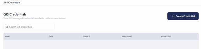
The GIS Credentials screen can be accessed by selecting Entities, then choosing GIS Credentials. If configured as a sidebar shortcut, GIS Credentials can also be accessed directly from the sidebar.
The GIS Credentials screen displays existing GIS credential records in a table.
Searching for GIS Credentials
To search for a GIS credential:
- Open the GIS Credentials section.
- Use the search bar on the GIS Credentials screen.
- Enter the credential name, source, type, or other available search information.
- Review the filtered results in the GIS credentials table.
- Select the credential record to review additional details.
Creating a GIS Credential
Users with the appropriate permissions can create a new GIS credential from the GIS Credentials screen.
To create a GIS credential:
- Open the GIS Credentials section.
- Select + Create Credential from the top right.
- Complete the fields provided on the credential form. Required fields are marked with an asterisk (*).
- Enter the credential details.
- Enter the credential secret information.
- Select Create Credential at the bottom-right corner of the page.
The create credential form includes the following sections:
The Credential Details section is used to enter basic information about the credential.
The Credential Secret section is used to enter the authentication information for the credential.
The Use Default AGOL Token Endpoint button can be selected to populate the default ArcGIS Online token endpoint.
GIS Credential Details Screen
Opening an existing GIS credential record takes you to the GIS Credential Details Screen.
To open an existing GIS credential record:
- Open the GIS Credentials section.
- Locate the credential in the GIS Credentials table.
- Select the credential record.
The GIS Credential Details Screen displays information associated with the selected GIS credential.